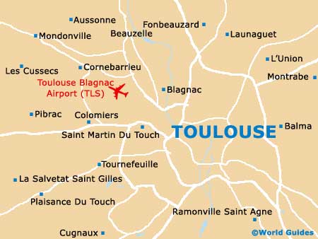
Toulouse Blagnac Airport (TLS)
City Orientation and Maps
(Toulouse, France)
The provincial city of Toulouse is famed for its impressive historic centre and is located on the south-western side of France. Toulouse is just a short distance from the coastline, with Montpellier, Béziers, Narbonne and Perpignan all being within easy driving distance.
On the other side of the city you will find Toulouse Blagnac Airport (TLS), which stands in the north-western region and is responsible for much of the city's popularity, with Montauban situated nearby and to the north of both the airport and the city itself.
Toulouse Blagnac Airport (TLS) Maps: Important City Districts
Within Toulouse you will find a circle of 19th-century boulevards, which surround a prominent bend in the scenic River Garonne. These streets include the Boulevard de Lascrosses, the Boulevard de Strasbourg, the Allée Jules Guesde, the Allée Charles de Fitte and the Pont Saint-Michel, which spans the river. Just outside of Toulouse city centre, the Canal du Midi encircles the area and joins the river, with much of the canal being lined with trees.
The old town area of Toulouse is divided by two main streets, the Rue d'Alsace-Lorraine, which stretches from north to south and is known for its excellent selection of shops, and the Rue de Metz, running from east to west and heading towards the Pont Neuf bridge.
The Gare Matabiau and the Gare Routière train stations stand next to each other and close to central Toulouse, on the Boulevard Pierre-Sémard, alongside the canal. A bus station is also nearby and features regular shuttles both to and from Toulouse Blagnac Airport. The main tourist information centre can be found next to the Charle-de-Gaulle square, which features attractive gardens and seating areas. Nearby, the Place de Capitole is Toulouse's main public square and is surrounded by many places to eat and explore.
France Map

Toulouse Map